Mapping Mountainous Arctic Lakes From the Air
Regional 3D lake mapping
Information about lake basins in Arctic mountainous regions is scarce. It is a difficult and costly task due to the sheer numbers and remote access for conventional technologies to resolve.
The latest technology of airborne bathymetric LiDAR has the potential to resolve the underwater lake landscape in such regions, as this type of LiDAR can penetrate the water and measure water depths.
The latest technology of airborne bathymetric LiDAR has the potential to resolve the underwater lake landscape in such regions, as this type of LiDAR can penetrate the water and measure water depths.
Regional 3D lake mapping
At about 200 km North of the Arctic Circle, in a mountainous lake rich region of Abisko, Sweden, a bathymetric lidar survey took place in August 2020. The airborne lake survey was a collaboration between Terratec Norway and Cristian Gudasz at the Climate Impacts Research Center of Umeå University and was gathered to test this technology for lake mapping and assist Cristian’s research, which seeks to understand how lakes function and their role in the carbon cycle at large scales and feedback loops.
Lake ecosystems in 3D
Many aspects of lake ecosystem functioning are tightly coupled to basin morphometry. For example greenhouse gas emissions, carbon burial or primary production depends on the type of lake basin shapes and sizes. Lakes can have a wide range of basin shapes and sizes, which can be dependent on regions. Hence, there is a need to have accurate lake depth maps or lake bathymetry at regional and larger-scales.
Bathymetry maps inform models
Accurate bathymetric data collected from lakes is important in large-scale models that capture climate and carbon cycle interactions such as the Earth System Models used by the IPCC.
Currently, one of the reasons the regional and global modelling does not account for the carbon cycle of lakes is because we do not have accurate bathymetry maps on a regional or global scale. This highlights the importance of understanding lakes in climate and carbon modelling; especially in a warming world.
Currently, one of the reasons the regional and global modelling does not account for the carbon cycle of lakes is because we do not have accurate bathymetry maps on a regional or global scale. This highlights the importance of understanding lakes in climate and carbon modelling; especially in a warming world.
Survey Method
The airborne bathymetric lidar survey equipment used by Terratec was the Teledyne Optech CZMIL Nova. This is a powerful and fast bathymetric surveying tool, offering the ability to create seamless elevation maps of land and water and other derived products. Next to the lidar a high-resolution camera is simultaneously taking images enabling the creation of a geospatial orthophoto.
Survey Method
Pictured here is the Terratec crew who took to the skies with the CZMIL Nova bathymetric LiDAR sensor over the Torneträsk catchment in the Abisko region.
The airplane used was a Cessna 208 Caravan, flying at 400 m above ground, with a speed of around 250 km/h.
The airplane used was a Cessna 208 Caravan, flying at 400 m above ground, with a speed of around 250 km/h.
Survey Method
Abisko region: 68°28’N, 18°25’E
Elevation: 400m
Hours flown: 2.5
Area covered: 50 km2
Flightlines: 34
Elevation: 400m
Hours flown: 2.5
Area covered: 50 km2
Flightlines: 34
Survey Method
After the survey the resulting datasets are processed. First the raw waveform data is combined with navigation data and calibrated, which gives a correct geospatial dataset.
The results is a geospatial point cloud, which is a collection of points that represent a 3D shape. Each point has its own set of X, Y and Z coordinates, as well as a classification (e.g. land surface, water surface, water bottom).
The results is a geospatial point cloud, which is a collection of points that represent a 3D shape. Each point has its own set of X, Y and Z coordinates, as well as a classification (e.g. land surface, water surface, water bottom).
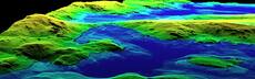
Initial results
Preliminary data processing revealed high resolution lake bathymetry coverage and depth up to 22m. The lake map shown here represents an example of seamless topography and bathymetry. The blue area shows a see through view of the 3D point cloud of the lake basin.
Initial results
An animated example through the lake 3D point cloud.
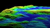
Initial results
Cross section of the point cloud of flight line 15. Blue point clouds are lakes at different elevations in the landscape.
Initial results
Point cloud detail of lake 15
Initial results
3D gridded water surface with orthophoto drape Lake 15.
Conclusions
Airborne LiDAR bathymetry using the CZMIL Nova has provided spectacular results in arctic mountainous lakes.
Even though the challenging terrain and weather can be limiting, this survey method is probably the most efficient option to survey inaccessible areas like this.
Replication of this project to other regions has the potential to greatly contribute to regional scale understanding of lakes climate and carbon cycle interactions.
Scroll down to continue
Swipe to continue
Swipe to continue


 Mapping Mountainous Arctic Lakes From the Air
 Regional 3D lake mapping
 Regional 3D lake mapping
 Lake ecosystems in 3D
 Bathymetry maps inform models
 Survey Method
 Survey Method
 Survey Method
 Survey Method
 Survey Method
 Survey Method
 Initial results
 Initial results
 Initial results
 Initial results
 Initial results
 Conclusions
