Mapping Mountainous Arctic Lakes From the Air
Regional 3D lake mapping
The latest technology of airborne bathymetric LiDAR has the potential to resolve the underwater lake landscape in such regions, as this type of LiDAR can penetrate the water and measure water depths.
Regional 3D lake mapping
Lake ecosystems in 3D
Bathymetry maps inform models
Currently, one of the reasons the regional and global modelling does not account for the carbon cycle of lakes is because we do not have accurate bathymetry maps on a regional or global scale. This highlights the importance of understanding lakes in climate and carbon modelling; especially in a warming world.
Survey Method
Survey Method
The airplane used was a Cessna 208 Caravan, flying at 400 m above ground, with a speed of around 250 km/h.
Survey Method
Elevation: 400m
Hours flown: 2.5
Area covered: 50 km2
Flightlines: 34
Survey Method
The results is a geospatial point cloud, which is a collection of points that represent a 3D shape. Each point has its own set of X, Y and Z coordinates, as well as a classification (e.g. land surface, water surface, water bottom).
Initial results
Initial results
Initial results
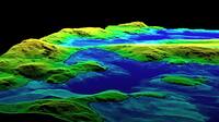
Cross section of the point cloud of flight line 15. Blue point clouds are lakes at different elevations in the landscape.
Initial results
Point cloud detail of lake 15
Initial results
Conclusions
Even though the challenging terrain and weather can be limiting, this survey method is probably the most efficient option to survey inaccessible areas like this.
Replication of this project to other regions has the potential to greatly contribute to regional scale understanding of lakes climate and carbon cycle interactions.


 Mapping Mountainous Arctic Lakes From the Air
 Regional 3D lake mapping
 Regional 3D lake mapping
 Lake ecosystems in 3D
 Bathymetry maps inform models
 Survey Method
 Survey Method
 Survey Method
 Survey Method
 Survey Method
 Survey Method
 Initial results
 Initial results
 Initial results
 Initial results
 Initial results
 Conclusions
